
LongLine
Professional-
Posts
3,917 -
Joined
-
Last visited
Content Type
Profiles
Forums
Events
Gallery
Store
Everything posted by LongLine
-
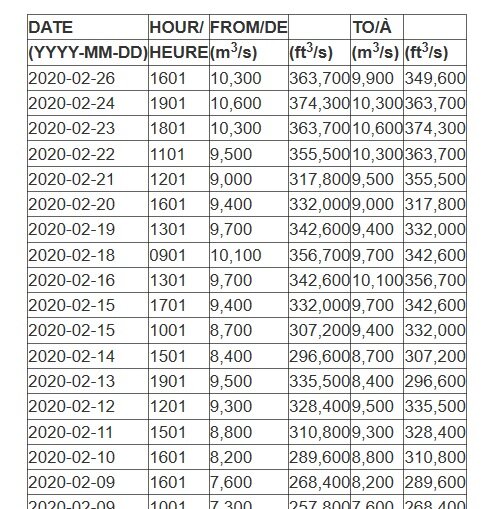
On 12/7/19 the outflow was 8,830 m3/sec. Except for 3 days in Oct, this is the lowest it's been since 5/31/19. In June, July & Aug it was over 10,000. according to the IJC water level site: https://ijc.org/en/loslrb/watershed/outflow-changes (scroll down for previous years) According to the GLFC water temp site: There is currently a very small pocket of water south of St Vincent being shown in the low 40's, however the deep section of the lake north of Sodus is in the 50's. (Yellow green) Normally this time of year the section off Sodus is in the very low 40's. The water currents map is also showing a strong twin gyre movement of water so IMO, it's going to be a while before we see substantial ice forming due to water temps. There are "Panamax", Post-Panamax", "Panamax Plus" and a "New-Panamax" style container ships. The "Post-Panamax" which they celebrated in Montreal only requires 11-13 m or 36-43 ft of draft. The "New Panamax" is the one that requires the 50 ft range draft and they haven't come in...yet. (that I know of. I believe it's a length issue) Tom B. (LongLine)
-
I would have expected the designers of Plan 2014 to have taken a look at the current measured data and anticipated or at least thought about what was going to happen. They took their eyes off of current data. (Perhaps they were too excited about working out selling the plan strategies for meetings and issuing press releases?) In the 12 years prior to 2013, all the upper lakes were at lower than normal levels then beginning in 2013 there was a definite beginning of an upwards trend in all the upper lakes levels yet Ontario maintained the same up/down 3-4 ft pattern because the outflow was being controlled until P-2014 took effect. Obviously they totally ignored what was going on with water levels from the point they drafted the plan and it's going into effect in Jan of '17. They had an additional 4 years of water level data that they did not take into account which would have changed the statistics in the written Plan 2014 document. It had already historically been proven that Ontario's level could be controlled to the 3-4 ft range when the upper lakes were way above there normal levels using the historical trigger points. However as you point out, P-2014 went into effect in Jan (and it has higher trigger points.) P-2014 is supposed to allow Ontario's level go higher and lower than normal yet in late 2018 they did not allow it to go to a lower than normal level. Even though the Army Corps and the Canadian Gov't both officially forecasted higher inflows for 2019. (BTW: in 2013 the 1st post-panamax ship arrived in Montreal (much heavier container ship) and in 2016 celebrated a record 35 Million tonnes of container freight and the records are going up - without dredging the port. P-2014 is designed with shipping in mind, not the landowner or recreationalist.) No dock talk here...they were under water & launches closed most of the year. Tom B. (LongLine)
-
https://www.lre.usace.army.mil/Missions/Great-Lakes-Information/Great-Lakes-Information-2/Water-Level-Data/ Superior was at all time high in '66 according to above army corps site. In fact all the lakes were very high that year EXCEPT Ontario. In fact they went down in next couple years and regardless of what the other lakes did in subsequent years Ontario maintained it's steady up/down 3 - 4 ft pattern. LTA-GLWL-Graph.bmp This indicates that the seaway control can indeed successfully react to whatever water levels are in the upper lakes and control Ontario's level but simply didn't in both '17 & '19. Plan 2014 didn't trigger the increased outflow until it was too late. If you buy the argument that the high water level in Ontario was due to the increased water level of the upper lakes then the framers of plan 2014 should have factored in the upper lakes levels into that trigger point. It would be nice if opinions were based on measured data, not on alternative facts proposed by those with vested interests in shipping. BTW, there are (as of this morning) 23 ships in transit from Niagara to Montreal. 11 in the actual seaway and the seaway is supposed to close end of month. According to H1 Criteria for "exceptions to high water level" in plan 2014, they get the priority before the landowners upward or downward of the power plant as well as the environment. Tom B. (LongLine)
-
The upper great lakes are at high levels, not at record high levels. Look at the graphs on this GLERL - NOAA site. https://www.glerl.noaa.gov/data/wlevels/levels.html#observations Note that all of the other great lakes levels traced through out this year are a little higher but almost exactly parallel to 2018. From April to June for Lake O, it's almost perpendicular to 2018. Look at all of the graphs earlier in 2019. Other lakes were a little higher than 2018 but Lake O was nearly the same as 2018. This should have been the signal to let more water out of Lake O in preparation for it. The should have opened the gates in March. Go back & read plan 2014 - not the media reports about it. It's first criteria is for navigation and power plants. Property owners are like 4th or 5th. (both above & below the power station) Floating docks - of course the little guy should bear the expense (& permit hassles) for them. ( BS! ) I-Bay has floating docks & they were closed for quite a period too.
-
Totally agree with you HB. Gat' & Luck - agree but those are narrow channels. Even at the Genny, you can have a wall of water washing fishermen off the banks when they open the gates. I'm thinking more along the lines of water seeking it's own level in large bodies very fast. Example being during a good storm seeing the water rise 22" at St Vincent with a corresponding drop at Rochester. But when wind dies, in just a couple hours the water level returns to where it was. Seems to me (& I could be wrong) we had a steady rise in water level then all of a sudden we had a much bigger than normal "whamo" all over the lake. The when the water dropped a couple inches in Oswego, it also dropped same in Olcott, not a week or month later. Tom B. (LongLine)
-
-
Sorry, but not true. As the level in the funnel goes down, (just as in any tank being drained from the bottom) the pressure from above becomes less & the velocity of the flow slows down. Same as with siphoning off the bottom of a full tank vs siphoning off the bottom of a near empty tank. (That's why in a zahn cup, you must use exactly the same level of liquid in order to compare viscosities) Tom B. (LongLine)
-
-
Brian - Thanx for the reply. very insightful. Unfortunately research often gives rise to more questions. I'm curious about the "condition" of the alewife. I see in the '18 report on 61/2" alewife growth graphs of spring vs fall, that these fish went from approx. 31.5 g to 33 g. I've read that fish farmers usually plan for their fish to consume 1-5% of their weight in feed daily so I have to ask if sampled alewife had substantial flea tails in them, hence skew the numbers? i.e any data on the typical weight of those stomach contents? Guys - As to "climate catastrophe" please remember that 2000-2012 Michigan/Huron had a period of very low water and even National Geographic ran an article about the lakes drying up due to "climate warming." Also consider we had a very wet month followed by a very dry month followed by a wet month followed by a dry month. Now consider the Lake Ontario Drainage Basin and all the heavy precipitation that went south of us. i.e southern tier, SE of us, etc. It didn't drain into lake Ontario - It went to the Chesapeake Drainage basin! Further consider that the International Lake Superior Board of Control (which controls the level of Lake Superior on the St. Mary's river system) on April 3rd 2019, after receiving permission from the IJC, opened their gates which were normally set at 1 gate 1/4 open at that time of year to 2 full open gates and keep it there in anticipation of late summer maintenance. We don't need to wait 2 yrs for Superior's water to get here simply because hydraulically, Superior pushes Huron's water which pushes Erie's water here. That process is a lot faster than waiting for Superior's water to get here. I believe we had the big spike in water level in June. Tom B. (LongLine)
-
Brian - I thought I remembered that statement about the fleas not having much nutritional value from a state of lake meeting a few years ago. One where they showed a picture of an alewife’s stomach content of fleas that looked like a miniature bird’s nest. Perhaps I’m wrong. I have seen literature though that small preyfish can’t eat them because of the tails and that larger preyfish have difficulty passing them through their digestive system due to the barbed tails. I am curious as to what the stomach contents of the alewives were, that were caught in the trawls. Paper doesn’t really say if they were fleshy, full or empty stomachs, etc. (just total weight and count per trawl) I am also curious as to whether there are chemicals in the fleas that can cause reproductive issues in the alewives just as it has been stated that alewives cause vitamin deficiencies, hence reproductive issues in the salmon. Any thoughts? Jimski – not sure how to read your post. Are you saying that someone who has lived near the water for many years and seen water levels controlled to within 3 feet (invested his life there; raised his kids there; paid extremely high property taxes; was forced to improve his property due to new regulations since he bought the place, etc) should simply pick up & leave? He should do this because some inept politicians were hoodwinked by big business (trying to get a longer shipping season for heavier boats) into believing it was for the greater good? He should have known that in the future a policy would come about that would allow water levels to fluctuate much more and damage his homestead. (?) Please remember when they built the seaway system and locks, the gov’t resettled an entire town before they built it and yet the IJC & 2014 flatly refused any consideration for property damages along the shoreline. In fact the IJC & 2014 ignored the concerns of the property owners as well as the boating & recreational industries. Assessments don't go down, never have. High water & flooding just scare potential buyers and make it harder to sell a place. Also, please note that 10,000 years ago, the west end lake bottom was a few inches different elevation than it is now. I guess that means all those people should move to the east end. (?) Tom B. (LongLine)
-
Bottom of food chain is the zooplankton. Section 3 of the 2018 annual NYSDEC lake Ontario report goes hot & heavy (and I mean heavy duty stuff) into chemical & zooplankton biomass analysis of Lake Ontario. Suggest a look at the graphs on pages 21 thru 25 (NYSDEC site) which show historical levels. Looks like there was a big drop off in biomass in 2015. Years '16, '17 & '18 show same levels or slight decrease except for Bythotrephes which now account for close to 20% of the total biomass. (Fleas - that came in on saltwater freighters from Europe) Alewives do eat fleas but unfortunately do not grow big & healthy eating them as they have very low nutritional value. I hope the alewives come back too, but IMO high water has been detrimental to the environment. Tom B. (LongLine)
-
Interesting link on Great lakes shipping from last October: https://www.maritime-executive.com/editorials/improved-prospects-for-container-ships-on-the-st-lawrence-seaway It's no longer bulk cargo. For a few years we've had small container ships coming in from the ocean. There's been a drive to make them heavier. i.e hold more containers per trip - to reduce the transport costs & get much cheaper than rail or truck from NYC. (offset tariff cost increases) Logically, they need greater draft clearance. Higher water level makes the narrow lane thru the river with appropriate depth a bit wider. And yes the Lamprey & alewife do pre-date the seaway. Tom B. (LongLine)
-
1 week data is good to see. However April thru May they dropped it drastically. (under 250K) Then Mid June thru Aug upped it to over 360K & held it there. Graph at bottom of that link. (Guess a lot of freighters got grounded over the summer ? How many couldn't come in under the old plan? ) Lake is still a foot & 1/2 higher than datum. As I recall, at the Nov meeting of River Planners & IJC, a topic that came up was to increase outflows & suspend shipping for remainder of year, but was shot down due to "economic impact would trickle down to US economy." IMO, shippers lobby just trying to beat tariffs that haven't been enacted yet. Also having high water much cheaper for the shippers than dredging a couple harbors or rivers. They obviously felt the little guy wouldn't mind paying for rebuilding his house, docks, boat house, or the ramps he uses. 2014 said no relief for losses. Relief (from state) didn't come till way after much damage done. Back on point, IMO, high water has caused more problems for the little guy whom the politicians think won't mind paying for their ineptitude. Environmental benefit was just an opportunity seized upon by big business as an emotional selling point to their plan. Higher water means higher volume of water; water will remain warmer longer in the year and will heat up faster due to shorter ice period; fish & prey going deeper where the little guy can't reach them, more lake affect precipitation; more erosion & less beach area; more "nasty" pollution washed off the land; more "nasty" algae & seaweed; more landowner damage by storms. I'm hoping we don't see a super cold winter & stormy spring because if we do, the ice flow out the seaway will be horrendous. Tom B. (LongLine)
-
Then they shouldn't have messed with it. Maybe they should have at least thought about ramifications and a little more detail of the entire system. i.e treat the disease, not the symptoms. True, it also contains a lot of pharmaceuticals which are currently high on the list of major pollutants in the lakes. I used to think that too until I realized they aren't located off shore and looked at the water current charts for the lake. Means it doesn't have to travel nearly as far. Edgemere, Beach & parts of the Parkway (& land) got washed really well and are ready for a lot more chemicals. If (big if) the chemicals are biodegradable, I'd rather they degrade on land than in the water. I also favor a slow release so that wildlife has a chance of adapting rather than the shock value of a major release. I'm all in favor of environmental stewardship but politicians really blew it! 2014 means they didn't allow substantial water out of the system until it was too late. FEDs kicked the sportsmen & landowners right in the teeth just so as to extend the shipping season and allow the freighters to come in longer in the year dumping what ever. (Remember NYS law about ballast exchange got shot down by Feds) What's the current outflow right now? Water should have gone down a lot more than it has. Tom B. (LongLine)
-
High water means more erosion and flooding of land owners property. Landowners (farmers) that have fertilized their lawns (fields) for years. Guess where that fertilizer has/is going. Unfortunately that "modern" stuff is going to help the wrong "seaweed" and wrong algae thrive. A few sewer systems/septics were flooded this last year. Guess where the sewage went. High water also means it'll take longer for any ice to form on the lake. It'll form in late Jan early Feb then be gone in late Feb or early March. i.e lake won't have ice on it nearly as long as it used to, hence lake will warm up much faster and higher temp will go much deeper later in summer. Baitfish reproduction is temperature dependent not depth dependent. The spawning runs are affected by temperature. Warmer lake late in year also means a lot more "lake effect" snowfall which means towns will use a lot more road chemicals that will eventually wash into you guess where. The environmentalists argument was that it would be good for the wetlands to be rinsed alternately high & then dry out with low water. The didn't consider wetlands staying high. (where are these wetlands anyway?) The environmentalists should have probably turned their attention to the birds. Anyone see the huge flocks of Canada Geese this year? Tom B. (LongLine)
-
-
Genny was closed yesterday. Water over N dock, South dock about 1/8" above water line.
-
I don't know much about the decking, but one thing to remember is that 4 riggrs in the water will put a lot of torque/twist/pull on the board brackets. Make sure you have a good solid backer plate under the gunnels. (Much wider and longer that whatever you attach the board to above the gunnels.) As to a metal board, I think a channel would work much better than a solid piece. Also, stainless is liable to get hot on a bright day so I wouldn't want my mono line to touch it late July. Tom B. (LongLine)
-
-
Here's what I did many many years ago, a hinged board & it's still going strong. (note I never leave gear in my boat) I placed two permanent pieces of aluminum bolted to gunnels with backer plate underneath: I use two screws per end to hold the board: (wing nuts locked in place on 1/4x20's) A hinged board allows me to get the riggers out away from the boat. Even tho' I've got extendable booms, I can swivel the riggers parallel to the boat to change lures (forward) & never have to worry about bouncing the weights off the side of the boat and don't have to lift the rigger. Also just hinge it upward to land at dock. Works for me. I would not use aluminum for the board. It will bend over time. Tom B.
-
Look at your engine when the boat turns. Did the engine turn? Some outboards will turn because of vibration and loose steering. In this case the engine just has to be held securely. Others turn because of the exhaust: The anode tab is usually installed at a little angle to the lower unit to help boat performance at higher speeds. At low speed, the exhaust pushes against it and the difference in water speed/pressure past it causes the boat to turn. In this case you have to "over-steer" a little in the opposite direction and securely hold it there. Anything you hang off to the side won't help if your being steered in one direction or the other
-
-
Like Brian, I'd like to see more on the low end but that isn't likely with the shipping interests on the lakes. Water is naturally blue and generally darker as the lake gets deeper. It means there's very little particulate suspended or dissolved in the water. Cloudy green usually signals algae growth, low oxygen & lots of nutrients. Neon green signifies "whiting" where calcium carbonate forms i.e. changes in water temp, low carbon dioxide & increases in photosynthesis. Blue-green generally means algae blooms. Browns denote "crap" in the water.
-

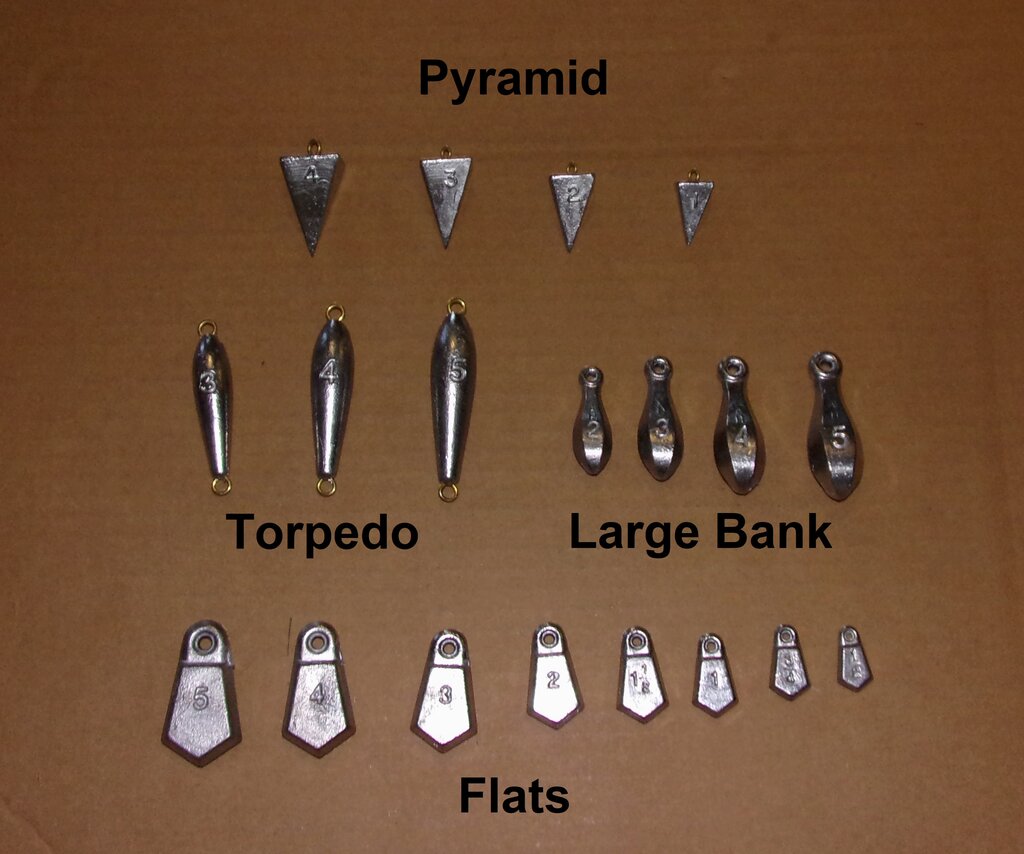
for sale : usa Sinkers, sinkers
LongLine replied to LongLine's topic in Classifieds - Buy, Sell, Trade or Rent


